Cassandra Brown, a UW Graduate Student in the Department of Urban Planning, did her master’s thesis on Lake City in 2020. It is called “A Visioning Document for Vibrancy in Lake City”. She studied the history of Lake City’s development, analyzed its current state, and made suggestions for how it could be made more vibrant. As she explains, “Urban vibrancy is the outcome of successful urban places –places that aspire to be seen, remembered and delighted in. They support community gathering, social exchange and often become places of cultural relevance. They incentivize people to walk to their destinations and to linger – improving personal health and creating safer streets.”
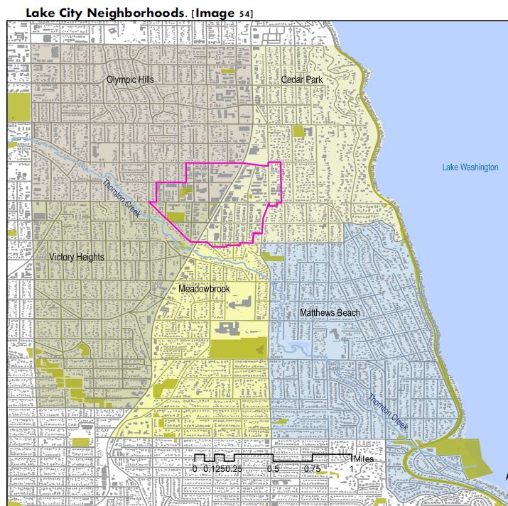
As she says, vibrancy is the end-goal of Lake City. We’d all like it to be a welcoming, thriving place with lots of things to do. Below is a map of the Lake City neighborhoods and the city center. The left boundary is 15th Ave NE; we can ignore the fact that Pinehurst is not labeled on the map!
Below, I’m copying verbatim mostly the history of Lake City, but you can read the entire paper here. It’s very interesting. Sorry for the formatting.
https://drive.google.com/file/d/1ZXOwhAHw9ktUS7GtsqdoSjCZUtfjX0PL/view
HISTORY
Though we often think of human development on a
spectrum of preserved lands where the natural
environment is reasonably untouched to urban; cities exist
within the natural context of the land and environment, not
independent from it. Michael Hough explores this concept
in Cities and Natural Processes: a Basis for Sustainability:
“Elements of the self-perpetuating biosphere that sustain
life on earth and which give rise to the physical landscape.
They are the central determinants that must shape all
human activities on the land,”
The landscape of the Pacific Northwest has been shaped by
glacial activity and at least four major geological events
over 2.4 million years. The Salish Sea, as we recognize it
today, was created by the most recent extension of the
Cordilleran Ice Sheet – the Puget Lobe, that advanced and
retreated over 5,000 years. This movement carved the
topography that has both challenged and protected people
here since time immemorial. Nested between the Olympic
and Cascade Mountains with steep grades and a deep port,
the Salish Sea region has been historically water-rich,
supporting travel and abundant food supply.
Today the Salish is regarded as a large watershed stretching
from Vancouver to the lower Puget Sound. It encompasses
the Straits of Juan de Fuca and Georgia, 470 kilometers of
coastline, 419 islands, and supports over 4,000 unique
animal species. The diversity of life and temperate climate
has supported bands of indigenous Salish peoples since
time immemorial. Before colonization, the people that
occupied this place had extensive trade routes reaching as
far south as Peru, complex social and cultural traditions
and an advanced knowledge of the land and sustainable
agriculture.
SEATTLE
On February 15, 1852, settlers Denny, Bell, and Boren set
out to find a port deep and calm enough to support
commerce. After making their land claims, a year later on
May 23, 1853, the three families filed to’ establish the
town of Seattle, where modern day Pioneer Square and
Downtown are now. The city of Seattle was built in the
pursuit of wealth and capitalism, though this vision was
not realized overnight. The historical city of Seattle was
surrounded by many competing municipalities, which
would become predominant neighborhoods.
The founders of Seattle envisioned a prosperous city and
went to work shaping the landscape to attract business.
The infrastructure that Seattle’s founding families
invested in includes: topographical alterations to
straighten the Duwamish river, straightening the Cedar
River to prevent floods south of Lake Washington, filling
tide flats to extend Seattle’s port, erecting hundreds of
pilings into muddy marsh lands to make the extension of
the railroad possible, and regrading Denny Hill – – all
unbeknownst to the founders, positioned Seattle to
benefit from the Klondike Goldrush of 1897-1898.
During this brief period, Seattle became a gateway city
providing stampeders with supplies and recreation.
“Seattle boomed; between July 1897 and March 1898 – in
the peak months of the gold rush – it is estimated that
Seattle merchants sold as much as $25 million in goods,
up from an estimated $325,000 in sales in all of 1896.
Seattle was on its way to becoming the leading city of the
Pacific Northwest, tripling its population from the time of
the gold rush to 240,000 by 1910.” Most annexations to
Seattle occurred during 1883-1910 because of this boom
in population, wealth and development.
LAKE CITY
The Lake City neighborhood of Seattle is within the Lake
Washington – Cedar River Watershed; and within this 11
square mile watershed, is Thornton Creek – a major
feature of the Lake City neighborhood. Local
archaeological discoveries and recorded oral histories
have led to a nearby cranberry bog harvested annually by
indigenous bands; longhouses that supported potlucks
and housed families through the winter months; remains
of loved ones; and sites of mythological importance. At
the Mouth of Thornton Creek where Matthews Beach is
now, the remains of indigenous sites have been
discovered, but have not been preserved:
The tu-oh-beh-dahbsh, [was] a small group that had
one house at the mouth of Thornton Creek and
possibly another at the mouth of McAleer Creek, the
outlet of Lake Ballinger. Those at Thornton Creek had
access to the large cranberry bog near its head at
what is now Northgate…The burial ground for this
group may have been located between the house sites
at a spot where children digging in the ground recently
found a 100-year old native skull… When the censuses
were carried out in the early 1850s as part of the
treaty-making process, the Sababsh together with
their relatives on Lake Sammamish were counted at
between 80 and 200 individuals.
Development in Lake City, however, occurred at a much
slower pace with agrarian uses persisting well into the
20th century. The area was first settled by loggers and
then Nordic immigrant farmers. Early development was
inhibited by transportation. The primary mode of travel
was on the waters of Lake Washington which contributed
to maintaining the rural character of region until the
arrival of the railroad and later popularization of the
automobile. Historian David Wilma writes that “in 1887,
Daniel Hunt Gilman and other investors built the Seattle,
Lake Shore & Eastern Railroad north along the shore
enroute to the coal mines at Gilman (later Issaquah). A
station was established north of the brick factory at Sand
Point. Someone posted a sign on a shed that read, “Lake.”
The tracks hugged the shoreline, limiting settlement to
one side of the tracks at the mouths of creeks. In the
1890s, an electric trolley line reached Ravenna to the
south, opening that area to residential development, but
the area to the north remained farmland [until] D. H. and
H. Lee purchased [and platted] the land around Lake
station from the Puget Mill Co. In 1906… and called it
Lake City,”
In 1911, not long after the land around Lake Station was
purchased to build residences, Lake City Way underwent
the first of several paving improvements making the
region, for the first time, accessible to surrounding urban
areas. Commercial activity developed along the highway
and during prohibition in Washington State (1916-
1933), flourished as entrepreneurs manufactured and
sold alcohol. Research by David Wilma found that Lake
City was a popular destination for illegal activities through
prohibition and then, after the repeal of prohibition,
maintained an active nightlife.
The sprawling nature of agriculture did not incentivize
economic clustering for any significant downtown, and
when the area did experience development along Lake
City Way, it was auto-centric, meaning that preference
was given to wide streets and ample surface parking
surrounding businesses. The neighborhood remained
unincorporated until 1947 when area residents founded a
sewer district. Lake City was annexed to Seattle in 1954
as part of “North Seattle.”
Following World War II, unincorporated Lake City saw its
most drastic growth with a population increase from
2,898 in 1920 to 17,500 in 1940. The population nearly
tripled over the next decade reaching a population of
43,680 by 1950. In 1990, the population had reached
69,000 and in 2000 it was 75,400. Decades of
disinvestment in city centers resulting from tax incentives
for home ownership, the availability of debt, poor urban
policies and technology innovations that enabled
households to locate further from urban centers
contributed to an increase in land consumption, but
overall decrease in density.
In summary, the evolution of form in Lake City has
occurred in the following steps. It was founded as rural
agricultural lands serving developing areas until the
popularization of the automobile and related
infrastructure enabled travel to the area. With
development then primarily located along the highway to
support a partially informal economy and the prevalence
of conflicting land uses and large tenants, the
unincorporated area was considered urban-fringe. The
uncoordinated and rapid residential development that
followed WWII then made it a suburb. Since its
annexation to Seattle and designation as a regional
growth area, it may be characterized as an ex-burb with
infill development encouraged within the urban-village
hub and along main corridors.
Despite its recent shift in morphology, its unplanned history
has created several challenges to cultivating development
and vibrancy. These challenges include persistent
conflicting land uses, large tenants, concentrated
development along a highway, and a lack of amenities such
as those enjoyed by Seattle residents in other
neighborhoods, most notably the presence of cultural
attractions like performing arts spaces and the prevalence
of third places.
Challenges to vibrancy in Lake City include block size, the
lack of pedestrian-generating cultural attractions, lack of
horizontal density, legibility of form, and the dominance
of Lake City Way – a state-managed highway that serves
as both a main street and thoroughfare. However, the
community also has a rich history, natural nodes that
support civic engagement, and ample surface parking
that can be repurposed to make midblock pedestrian
pathways and meaningful civic spaces in the time of the
pandemic.

Leave a Reply